
In the world of broadband network design, precision and efficiency are paramount. Traditionally, Computer-Aided Design (CAD) software has been a staple for creating detailed blueprints. However, as the complexity of broadband deployments increases, particularly with initiatives like the Broadband Equity, Access, and Deployment (BEAD) program, Geographic Information Systems (GIS) are emerging as the more powerful and versatile tool. This article delves into the key advantages of using GIS over CAD for broadband network design, demonstrating why it’s the smarter choice for modern ISPs.
The Limitations of CAD in Broadband Design
CAD software excels at creating precise 2D and 3D drawings. However, when it comes to the vast, geographically dispersed nature of broadband networks, CAD falls short. It primarily focuses on the “what” of design—the layout of cables and equipment—without adequately addressing the “where.”
- Lack of Spatial Context: CAD drawings often lack the crucial spatial context needed for effective network planning. They don’t readily integrate real-world geographic data, such as terrain, existing infrastructure, and property boundaries.
- Limited Data Integration: Integrating data from various sources, like demographic information or environmental factors, is cumbersome in CAD. This hinders comprehensive network analysis and planning.
- Difficulty in Route Optimization: Optimizing network routes based on real-world constraints, such as terrain and right-of-way availability, is challenging in CAD.
- Inefficient Collaboration: Sharing and collaborating on CAD drawings across multiple teams and stakeholders can be complex and time-consuming.
The Advantages of GIS for Broadband Network Design
GIS, on the other hand, is specifically designed to handle spatial data and perform geographic analysis. This makes it an ideal tool for broadband network design, offering several key advantages.
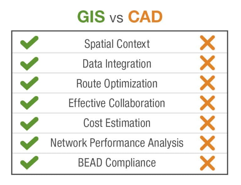
- Enhanced Spatial Awareness: GIS provides a comprehensive view of the network’s geographic context, integrating data from various sources, including satellite imagery, aerial photos, and LiDAR data. This allows for more informed decision-making.
- Seamless Data Integration: GIS can seamlessly integrate diverse datasets, such as demographic information, land use data, and existing infrastructure maps. This enables ISPs to analyze network performance, identify potential challenges, and optimize network design.
- Advanced Route Optimization: GIS tools can analyze terrain, road networks, and other geographic constraints to optimize network routes, minimizing construction costs and deployment time.
- Improved Collaboration and Communication: GIS platforms facilitate collaboration and communication among teams and stakeholders through web-based interfaces and data sharing capabilities.
- Accurate Cost Estimation: By integrating data on terrain, infrastructure, and material costs, GIS can provide accurate cost estimations for network deployments.
- Efficient Permitting and Right-of-Way Acquisition: GIS can help identify property boundaries, easement locations, and environmental constraints, streamlining the permitting and right-of-way acquisition process.
- Network Performance Analysis: GIS can be used to analyze network performance data, identify areas with poor coverage, and optimize network design for improved performance.
- BEAD Compliance: GIS is invaluable for the collection and reporting of the geographic data required for BEAD compliance.
Bridging the Gap: Integrating GIS and CAD
While GIS offers significant advantages, CAD may still have a place in your overall engineering design. Once design is completed geospatially, we suggest leveraging GIS platform interoperability with CAD software for complex permitting tasks.
Strata Networks Lehi City Telecommunications Planning and Design
Strata Networks is the largest independent telecommunications cooperative in the state of Utah, with more than 70 years of service to the Uintah Valley. The company wanted to expand its footprint to bring the benefits of fiber-based internet to more people but needed assistance to help them scale their business and grow quickly.
Strata selected HR Green for our understanding of both technical design and operational needs, implementing a geospatially-based Fiber Management System (3-GIS) and Construction Management System (Render). Lehi City, Utah, chose Strata to build and operate its municipally-owned network. HR Green helped Strata identify technology, processes, and operational improvements for growth. HR Green completed preliminary planning and cost estimates for 22,000 homes and businesses, creating a High-Level Design (HLD) for backbone routes and cabinet locations. The broadband design team provided fiber-to-the-home design services for over 475 miles of network using aerial, underground, and microtrench methods.
“GIS revolutionizes broadband network design by offering superior data organization and analysis capabilities – truly invaluable for the requirements established for BEAD compliance.”
-Ed Barrett – Broadband Business Unit President | HR Green
The Future of Broadband Network Design
As broadband networks continue to expand and become more complex, GIS will play an increasingly vital role in their design and deployment. Its ability to handle spatial data, integrate diverse datasets, and perform advanced analysis makes it an indispensable tool for ISPs looking to build robust, future-proof networks. By embracing GIS, ISPs can optimize network design, reduce costs, and accelerate deployment, ultimately bridging the digital divide and bringing high-speed internet to everyone.
Contact our Broadband team today to discover how we can help you reduce costs, accelerate deployment, and bring high-speed internet to everyone.
Contact Our Broadband Team