Aging infrastructure, changing drainage patterns, and recurring flooding continue to challenge communities across the country. While flooding impacts are often visible, the underlying causes are frequently much more difficult to identify.
A flooded yard may originate from an undersized pipe several blocks away. Multiple complaints in a neighborhood may stem from the same cause or could be caused by completely unrelated sources.
Stormwater master planning provides communities with a clear understanding of drainage system performance, helping identify root causes, evaluate solutions, and prioritize projects based on risk, benefit, and community needs.
Define Stormwater Planning Goals and Engage Key Stakeholders
Start with the basics: where people live, how land is used, where creeks and tributaries run, and which agency owns which pipe or channel. That picture separates aging infrastructure and undersized capacity from other causes of flooding.
Early coordination with the municipal project manager establishes goals, scope, and schedule. Public services, planning, finance, parks, fire, and police departments each contribute valuable perspectives on infrastructure, budgets, recreation, and emergency access.
Where jurisdiction is shared with a county, state DOT, or regional sewer district, early coordination helps identify regulatory requirements and planned improvements before they become conflicts. It’s also worth evaluating whether local ordinances need updating.
Early engagement with residents and elected officials can provide valuable local knowledge, help validate technical findings, and build support for implementation.
What Data is Needed for a Stormwater Master Plan?
Most plans should start with existing records: complaint logs, maintenance histories, prior studies, record drawings, staff knowledge, and GIS layers, supplemented by:
- Zoning and floodplain ordinances
- Topographic and soil data
- Wetland delineations
- FEMA floodplain mapping
Nearby sewer districts, counties, and transportation agencies often hold additional pieces worth requesting early.
Initial review should separate active problems from issues already slated to be addressed through maintenance or capital projects so field investigations can focus on current needs.
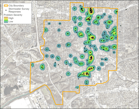
Public input fills in the gaps. A resident questionnaire is one of the most reliable ways to collect problem locations and conditions consistently, covering:
- Location and type of problem
- Frequency
- Depth or extent
- What’s affected (building, road, yard, etc.)
- Photos or dates from past events
Mapped alongside existing facilities, these responses begin to tell a story. A cluster of reports along one street may indicate a single system deficiency rather than multiple unrelated flooding issues.
Build a GIS Database for Stormwater Planning
An updated GIS database is the backbone of the process, bringing infrastructure records, complaints, and field findings together in one location. A typical database includes:
- Storm sewers, inlets, manholes, and culverts
- Open channels
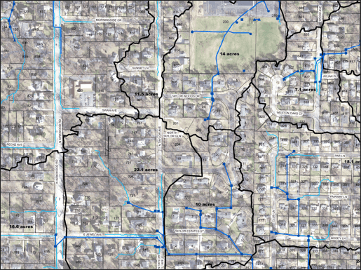
- Topography, drainage areas, and flow paths
- Detention and water quality facilities
- Known problem locations
- Completed and identified capital projects
Tracking ownership is equally important since it indicates who is responsible for maintenance and improvements.
Source data rarely arrives clean. Datasets often need to be supplemented with record drawings, survey data, LiDAR, and field observations, especially when used for hydraulic modeling.
GIS can also be leveraged to identify areas with the potential for flooding or erosion. LiDAR can help identify flow paths and areas where runoff naturally accumulates. Comparing these areas with complaint data can help validate resident concerns and prioritize areas for further study.
Staff can continue updating the database as problems are resolved, turning the master plan into a living resource. A well-maintained GIS database also serves as a long-term tool for asset management, complaint tracking, maintenance planning, and future capital project development.
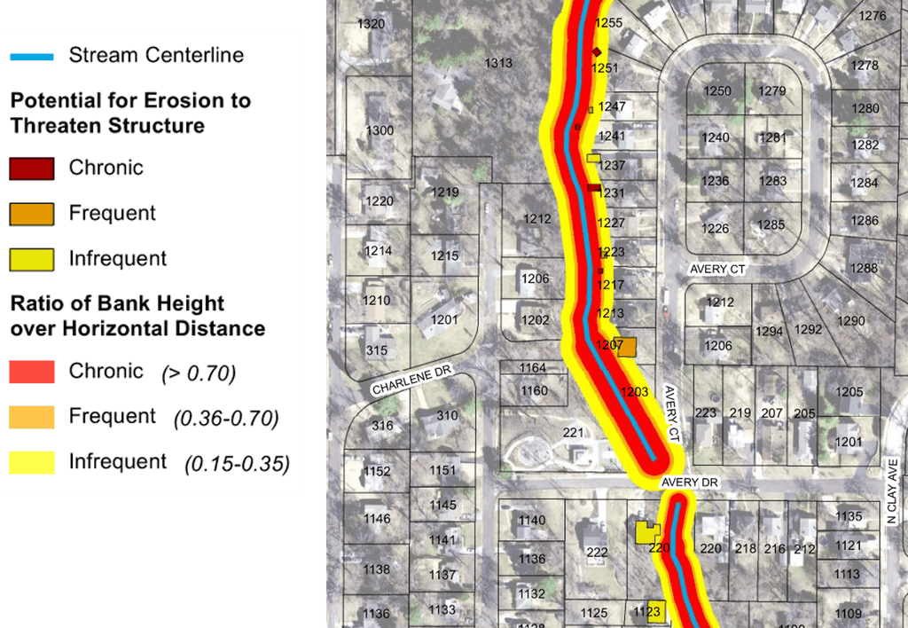
Use Hydraulic Modeling to Evaluate Stormwater System Performance
A hydraulic model can be used to evaluate system performance and compare existing conditions with proposed improvements. Hydraulic models are helpful when evaluating areas with complex routing, such as low flat areas where drainage flows multiple directions, areas with existing or proposed detention, or areas drained by large storm sewer mains.
The modeling approach should match the problem being evaluated. Simpler systems may only require pipe and channel modeling, while areas with significant surface flooding often benefit from integrated 1D/2D analysis.
Any hydraulic model should be checked against observed conditions, including photographs, high-water marks, past flood reports, rainfall records, and firsthand accounts. Model results that do not match observed conditions deserve additional review and adjustment.
Regardless of the software selected, model reliability depends more on data quality, calibration, validation, and engineering judgment than on the modeling platform itself.
Why Are Field Investigations Important in Stormwater Planning?
Field investigations are important because they help confirm the severity and source of drainage problems and identify conditions that may not appear in existing records or mapping. Desktop work should never be the last step before design. Field visits help to confirm the severity and source of the problem. Visits to the site are also an opportunity for us to speak with the affected property owners, who can provide valuable insights into what is happening.
Field investigations catch what maps miss:
- A pipe that looks intact on paper may have collapsed underground.
- A channel may be choked with debris.
- A recent street overlay may have reduced the capture efficiency of an inlet.
- A reported stormwater problem may turn out to be a private drainage issue or a mislabeled sewer backup.
- High water marks may be observed on properties that never submitted a complaint.
Site visits can clarify which complaints are related. Some may trace back to one fixable cause, while others that look related on a map turn out to need separate solutions. Furthermore, a single area may be experiencing flooding due to more than one deficiency in the system, such as poor inlet capacity as well as insufficient pipe capacity.
Common Misconceptions About Stormwater Systems
Stormwater planning often requires communities to challenge assumptions about how drainage systems function. Several common misconceptions can lead to inefficient investments or incomplete solutions:
- The location where flooding occurs is always the source of the problem.
- Every drainage complaint requires a capital improvement project.
- Larger storm sewers always provide the best solution.
- Hydraulic modeling can replace field investigations.
- The most expensive projects provide the greatest community benefit.
Effective stormwater management requires understanding how watershed processes, infrastructure limitations, maintenance conditions, and future development patterns interact. Comprehensive evaluations often reveal more effective solutions than those suggested by visible symptoms alone.
Evaluate Stormwater Improvement Alternatives and Estimate Costs
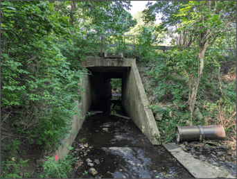
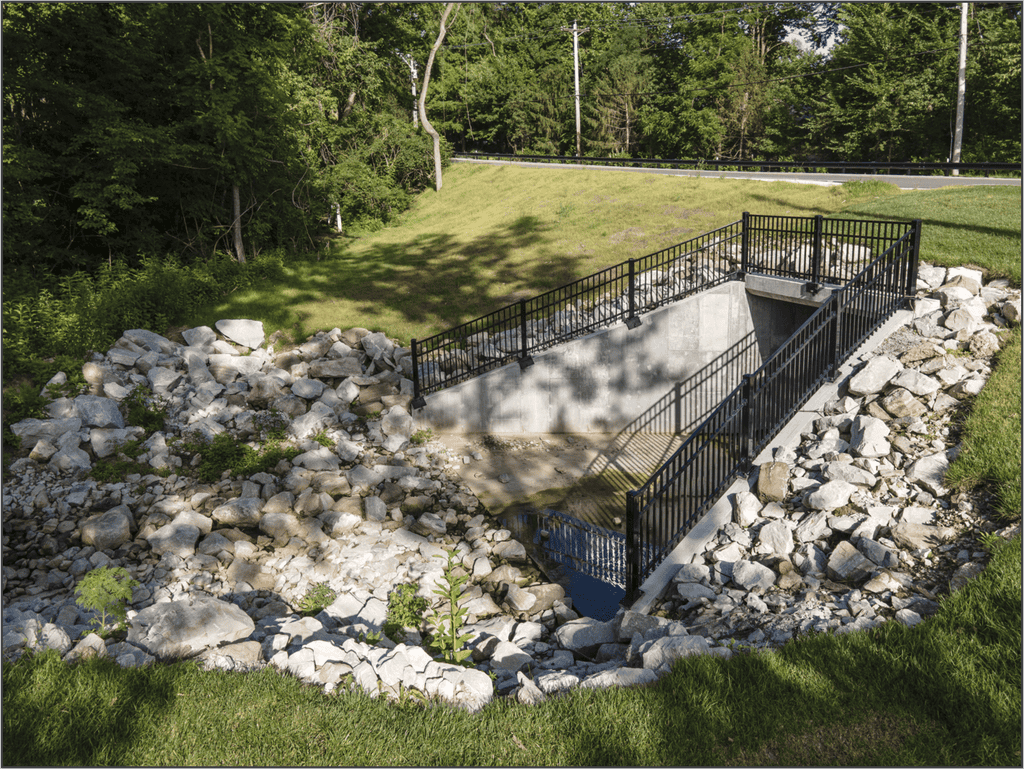
Once a priority problem is confirmed, a conceptual solution can be developed based on the cause, ranging from pipe or culvert upgrades to detention facilities, channel improvements, regrading, or inlet capacity improvements. The most effective alternatives consider conveyance capacity, inlet capacity, overland flowpaths, flood risk reduction, long-term maintainability, and future system needs.
Hydraulic performance is only one consideration. Each option should also be evaluated for property impacts, easements, utility conflicts, permitting requirements, constructability, and construction access so potential issues can be addressed before design progresses.
Cost estimates should match the timeline: near-term projects need preliminary design and construction-level numbers, while longer-horizon ones can carry planning-level totals with assumptions documented for later refinement. Estimates should account for engineering, right-of-way, construction, contingencies, and long-term maintenance, not just construction costs.
A useful project exhibit covers the problem, the proposed improvement and limits, anticipated benefits, conceptual cost, and key constraints. These exhibits serve double duty: technical documentation for staff, and a version elected officials and residents will actually understand.
Prioritize Stormwater Projects Based on Risk, Benefit, and Community Needs

Project prioritization should focus on identifying investments that provide the greatest overall value to the community, not simply ranking projects by cost or severity. The most effective prioritization frameworks balance engineering performance with public safety, community benefit, operational impacts, regulatory requirements, and long-term resiliency.
A roadway overtopping near a school, emergency response route, or critical utility corridor may warrant greater priority than localized nuisance flooding in a less impactful area. Evaluating projects through a broader community lens helps ensure investments are directed where they provide the greatest community benefit.
Benefit-cost ratios are useful, but they should be considered alongside factors such as flood risk, resiliency, water quality, level of service, and public support.
A points-based system focused on flooding impacts rather than property value helps ensure chronic problems are evaluated more consistently across the community. Where a regional funding partner uses its own ranking method, aligning with it can help position projects for outside dollars, but staff should still check results against their own operational knowledge before finalizing anything. Well-documented project needs, alternatives analyses, and prioritization frameworks can improve competitiveness for state and federal funding opportunities.
Maintenance work deserves its own list. A clogged inlet or short pipe repair may not score as high as a major flood-reduction project, but it can often be completed quickly and deliver visible results. Separating maintenance needs from capital improvements helps ensure smaller projects receive appropriate attention.
Turning Stormwater Recommendations into an Actionable Plan
Stormwater master planning is both an engineering and financial planning tool.
While engineering analysis may identify numerous improvements, communities must determine how to allocate available resources. Effective plans distinguish between immediate maintenance needs, short-term improvements, and long-term infrastructure investments. This phased approach helps address critical risks while positioning larger projects for future funding opportunities.
A prioritized project list does not become a program until it is tied to funding and implementation schedules. Organizing projects by priority, cost, and timing helps communities identify funding gaps and establish a realistic path forward.
Lower-priority projects should remain documented so they can advance if conditions, regulations, or funding opportunities change. Keeping these projects within the overall planning framework allows communities to adapt as needs evolve.
The plan should also identify the next steps after project selection, including survey, design, utility coordination, easement acquisition, permitting, bidding, and construction. Understanding these implementation requirements helps municipalities move projects from planning to construction more efficiently and develop realistic capital improvement programs.
Finalize the Stormwater Master Plan and Plan for Future Needs
Staff review of draft findings helps verify assumptions and incorporate operational knowledge, while public review provides another opportunity for feedback before recommendations are finalized.
The final plan should include recommended projects, conceptual cost estimates, priority rankings, and supporting documentation, with the GIS database and model serving as ongoing planning tools. It should also account for future land use, redevelopment, and changing community needs so today’s investments continue to provide value as conditions evolve.
By combining public input, infrastructure data, field investigations, and technical analysis, a stormwater master plan gives communities a practical framework for making sound infrastructure decisions. It can guide investments, support funding opportunities, and help communities manage risk and strengthen long-term resilience.
If your community is ready to better understand why problems are occurring and where investments can have the greatest impact, connect with HR Green’s stormwater team to discuss your next steps